For as in the days that were before the flood they were eating and drinking, marrying and giving in marriage, until the day that Noah entered into the ark, and knew not until the flood came, and took them all away; so shall also the coming of the Son of man be. Then shall two be in the field; the one shall be taken, and the other left. Two women shall be grinding at the mill; the one shall be taken, and the other left. Watch therefore; for ye know not what hour your Lord doth come. - Bible, Matthew 24 (38-42)
Water mills in Velzeke
In 1817, Jacobus Vanderstraeten was the miller at Pede's Mill. In 1858, his son Vincent protested against the construction of a « water mill to thresh and grind cereal in Velzeke-Ruddershove » by farmer Maria Anna De Paepe, widow of Norbertus Buysse(see note). The miller of our water mill claimed that the construction of this new mill was planned on the same watercourse, at a distance of only 400 metres, and that the brook already had an insufficient water capacity to operate one mill. However, the official investigation concluded that the new mill was not situated on the same brook.
Our first attempts to confirm the existence of this new mill in the immediate vicinity of Pede's Mill did not yield any results. No trace whatsoever can be found on maps or in archival documents.
On the territory of Velzeke-Ruddershove, situated just across the border of Hundelgem - border delimited by the brook - only two water mills are known: the « Driesmolen » and the « Van Themshesmolen ». However, both water mills are already mentioned in 1825 and were therefore already in use before the construction plans of Maria Anna De Paepe.
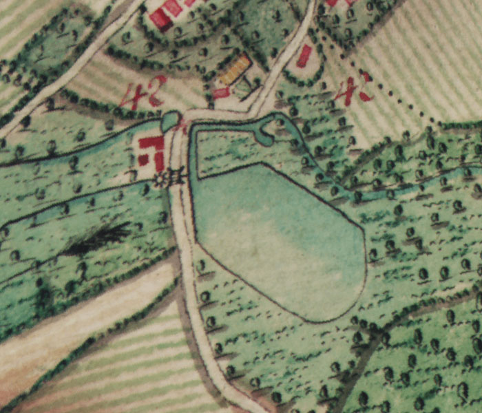
The « Driesmolen » is located on the « Molenbeek » (literally « Mill Brook ») and probably dates from the 17th century. Moreover there is an inscription with the date 1708 on the wall above the water wheel, which again clearly refers to a reconstruction date. The illustration below, a detail of the Ferraris map from 1777, shows the branch of the brook Molenbeek and the large mill pond. Such ponds were often built to have enough water in the dry season. The water was held up in the pond before a mill session and discharged again with a manually operated sluice during the milling process, to ensure a sufficient continuous water supply.
Illustration #4-1: Mention of the Driesmolen on the « Cabinet Map of the Austrian Lower Countries and the Principality of Liège » (1777).
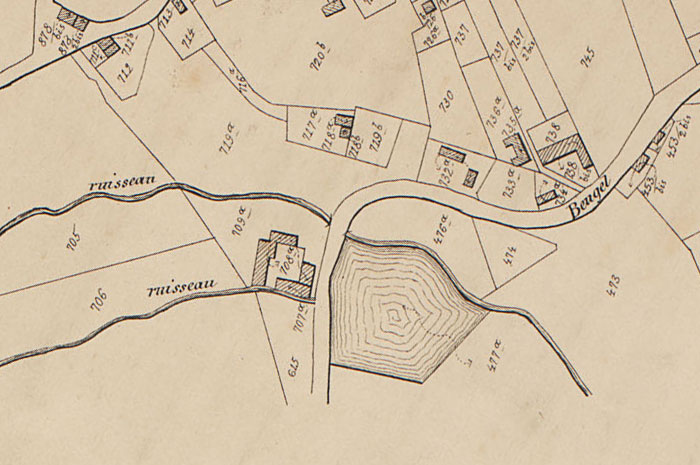
A more recent representation of the Driesmolen can be found on the Popp map of Velzeke.
Illustration #4-2: Mention of the Driesmolen on the « Plan Parcellaire par Philippe-Christian Popp » (Land Registry Parcel Map of Belgium) (around 1850).
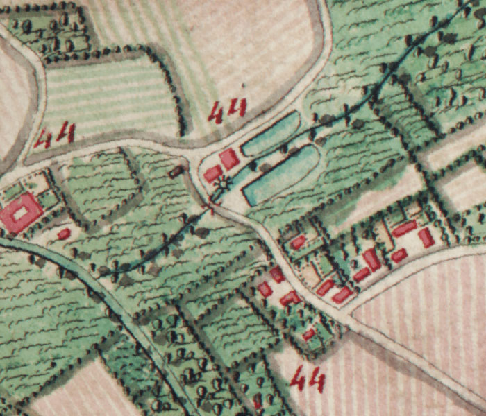
The second water mill in Velzeke, the Van Themshesmolen, was situated on the corner of the Knutsegemstraat and the Paddestraat and was also fed by the Molenbeek. It seems to have been built before 1800, commissioned by the investor Van den Boogaerde from Bruges. The only remains of this water mill are some crumbled walls covered with plants. The overshot water wheel and all the interior mechanism have long since disappeared. On the Ferraris map we see the mill and the two mill ponds along the Molenbeek, just before it flows into the Zwalm River.
Illustration #4-3: Mention of the Van Themshesmolen on the « Cabinet Map of the Austrian Lower Countries and the Principality of Liège » (1777).
We also find the Van Themshesmolen and its two mill ponds on the Popp map of Velzeke.
Illustration #4-4: Mention of the Van Themshesmolen on the « Plan Parcellaire par Philippe-Christian Popp » (Kadastraal Plan) (around 1850).
Competing mills
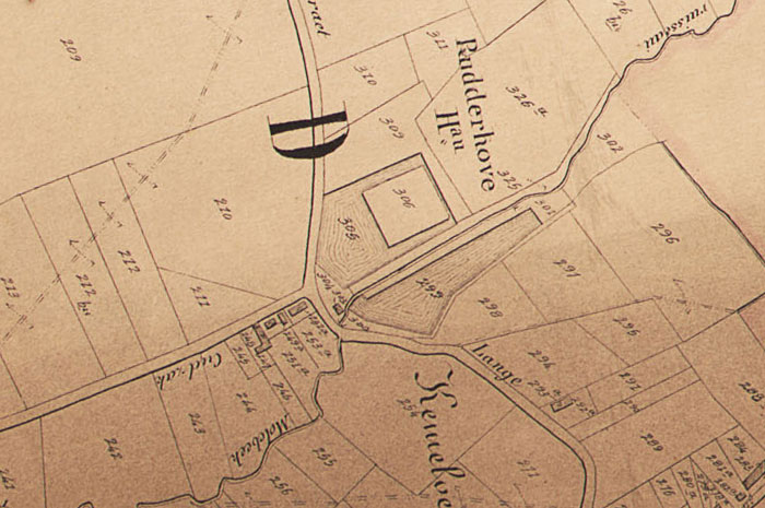
For quite some time, it was unclear if the mill, against which miller Vincent Vanderstraeten protested, was actually ever built, nor where it would have been located. No maps or building plans have been found. However, the Popp map of Hundelgem, which we mentioned previously and dates from the second half of the 19th century, points us in the right direction. As we have seen before, each map was accompanied by a specific table, displaying information about each parcel: the owner, the size of the parcel, usage of the land and land revenue.
The official investigation conducted in response to the building application and the opposition shows that Norbert Buysse's widow had plans to have a water mill built on a plot she owned.
We refer to an extract from the book by Paul Huys « Molens en molenaars te kijk gesteld » (free translation : « Daily life of Mill and miller) »:
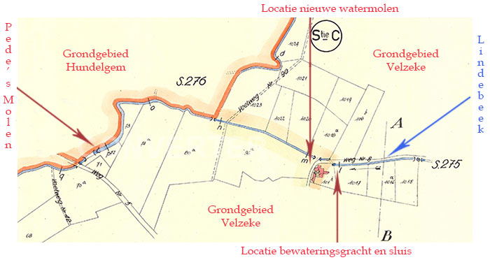
Miss Maria Anna De Paepe, widow of Norbertus Buysse, farmer and owner in Velzeke-Ruddershove, asks for authorization to build a water mill to thresh and grind cereal, to be erected in her orchard (Section C 96); she also asks for the construction of a water canal, by blocking the brook known as Linderbeke where it passes under the road #6 by constructing a sluice at the north west corner of parcel C 1017. There is written opposition by Vincent Vanderstraeten, miller in Hundelgem, because his water mill is situated on the same brook at a distance of only 400 meters and given the insuficient water capacity of this brook. However, the research that was conducted shows that his mill was located on another brook (Noenborre). Advice B&S 16th July 1858. Agreement BD 19th July 1858 (11 operating conditions). The authorization was withdrawn two years later by Decree BD of 11th August 1860. Not mentioned in PMI."
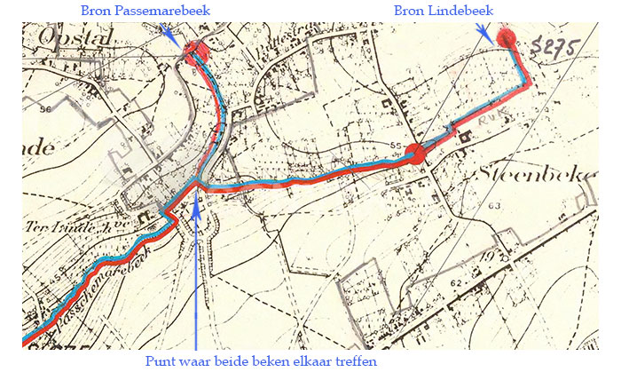
The name « Linderbeke » shows the confusion we have noticed when we have consulted the descripcion of the various « brooks » in Velzeke in the official sources. The « Lindebeek » is considered to be an affluent of the « Passemarebeek », but when we consult different detailed maps, we could argue that it is not the Passemarebeek that flows into the « Lindebeek », but quite the opposite.
Illustration #4-5: The Passemarebeek and the Lindebeek on the cadastral map of Velzeke from 1967. The locations where both brooks originate are inditated by the blue arrows at the top of this illustration. The blue arrow starting from the bottom margin of this illustration indicates the exact spot where both brooks meet.
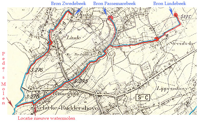
In a radius of 400 meters around the Pede's Mill, a possible location for the newly planned water mill can be found along the aforementioned Passemarebeek (see ilustration below). The official research mentioned in the extract from the book had reached an incorrect conclusion. Pede's Mill is situated at the confluence of a number of brooks and the mill that was going to be built would undoubtedly have had an influence on the available water supply, because the temporary retention of water in a brook always has a direct impact on the water mills downstream and can drastically lower the water level and available water supply. Besides, the Zwedebeek is indicated in a certain number of archival documents as « Noenborre », which is the name we saw earlier on in the official request.
Illustration #4-6: Pede's Mill and the possible location of the new water mill on the cadastral map of Velzeke from 1967. The locations where the three brooks originate are inditated by the blue arrows at the top of this illustration. The red arrow starting from the bottom margin of this illustration indicates the spot where the new water mill would have been built, very close to Pede's Mill.
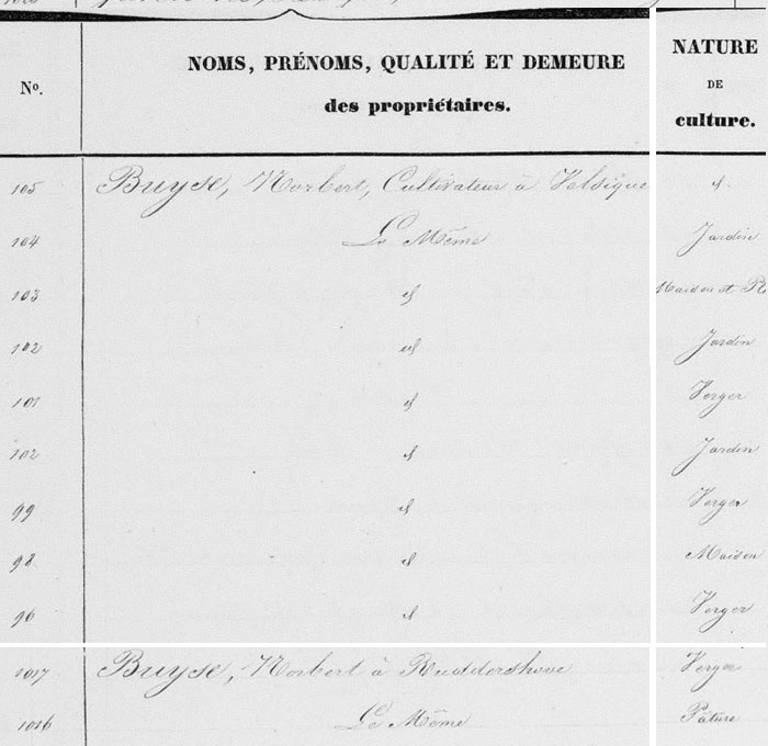
The table accompanying the Popp map of Velzeke, which includes a list of plot numbers and their owners, shows us the exact location. Norbert Buysse's widow owned a large number of parcels, some of which were adjacent to the miller Vincent Vanderstraeten. Plots 96, 99 and 1017 are registered as orchards and are located along the brook which also feeds the Pede's Mill. On later maps, parcels number 96 and 99 appear to have been merged since then.
Further information that we have recently obtained personally from the current owners of the plot and from the neighbour confirms that this plot was once owned by Norbert Buysse.
Illustration #4-7: Extract from the table that accompanies the Popp map of Velzeke.
The location of the plots and the Pede's Mill are indicated on the following two maps.
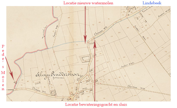
Illustration #4-8: Pede's Mill (on the left) and the location of the planned water mill on the cadastral Popp map of Velzeke from 1877, indicated by the red arrow starting from the top margin of this illustration. The red arrow starting from the bottom of this illustration shows the possible location of the planned water canal and sluice.Illustration #4-9: Pede's Mill and the location of the planned water mill on the cadastral Popp map of Velzeke from 1950, indicated by the red arrow starting from the top margin of this illustration. The red arrow starting from the bottom of this illustration shows the possible location of the planned water canal and sluice.
We believe that the mention « water canal » means that the brook would be made wider at this point, in order to create a small mill pond. Retaining water at this point would mean halving the amount of water available for lower situated water mills on this very brook from the moment the sluice is closed. Although Pede's Mill got its water from different brooks, as we have seen earlier, the impact of a newly built water mill on one of the brook would have been noticeable and could have reduced the water supply by half.
Subsequent land register data do not mention the construction of a water mill at this location. So it's likely that this new water mill was never built. The passage quoted above mentions a building permit that was granted on July 19th 1858, with 11 operating conditions. However, this permission was withdrawn two years later by a Decree of August 11th 1860. It is possible that the construction of this water mill was not considered economically viable.
Gradual decline of Pede's Mill
We get back to our water mill to describe the events during the last part of the 19th century and the 20th century. At the death of Jacobus Vanderstraeten, came into the possession of his widow and after her death in 1880 the mill was inherited by her two children, Lowewijk and Vincent. Vincent Vanderstraeten died in 1890 and his brother Lodewijk in 1899. By inheritance, the water mill came into the possession of Lodewijk's widow, Delphine Verheyden (alias Adolphina Baele). On April 7th 1902, she sold the mill to miller Emile De Geyter and to farmer Lodewijk De Geyter from the nearby village of Nederzwalm. Lodewijk withdrew from the community of properties in 1906.
In 1933, the mill was sold to miller Ivo Dujardin-Haegeman and on November 28th 1938 to Benjamin Pede - De Clercq, who gave the mill its current name. The last miller was Robert Flamand(see note). He rented the mill from the owner Benjamin Pede - De Clercq in the 1950s and halted the mill in 1959 after a technical breakdown.
The building stood unattended for some time and several small objects and tools were stolen. On August 26th 1965, at the notary Van de Beken, the complex consisting of « a house with annexes, storage, a barn and a former water mill » was purchased by the building contractor Clement R. A. Roelens - Vernailen. From this description, we can deduce that the mill was no longer in operation in 1965. In March 1969, Emiel Van De Catsijne - Ogiers, a real estate trader from Gembloux (in the south of Belgium), bought the complex and furnished the miller's house as a country residence.
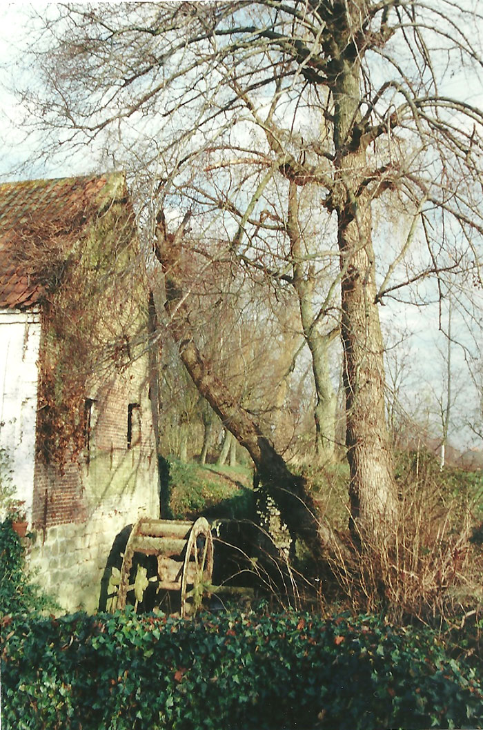
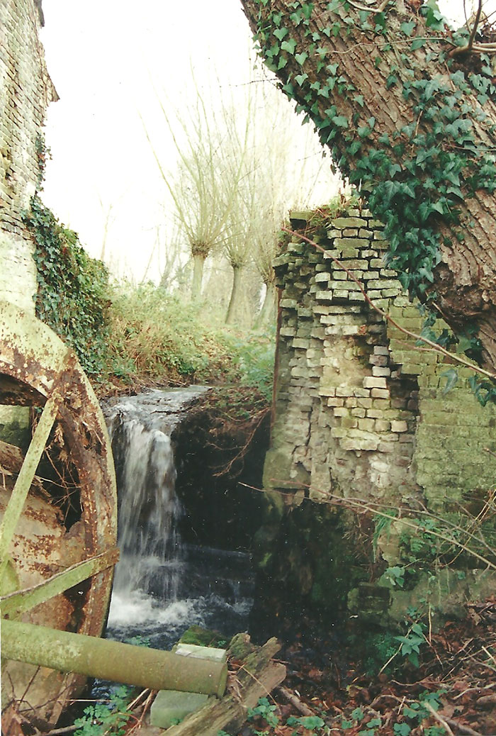
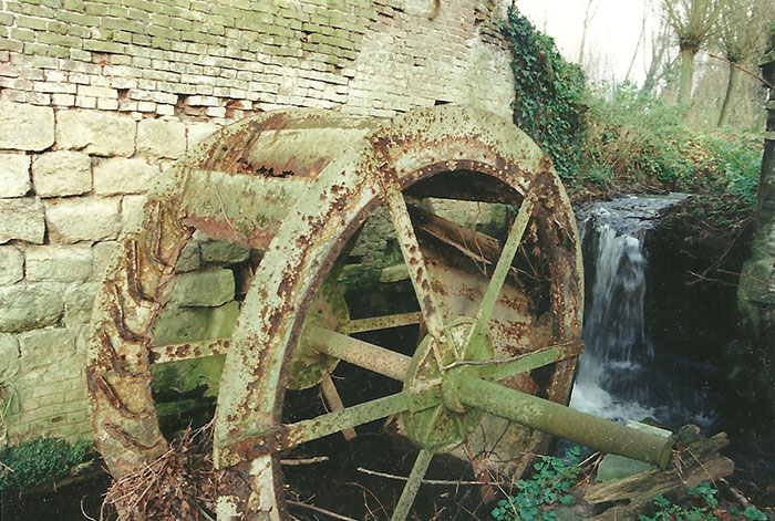
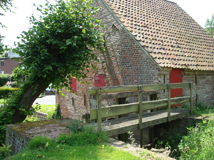
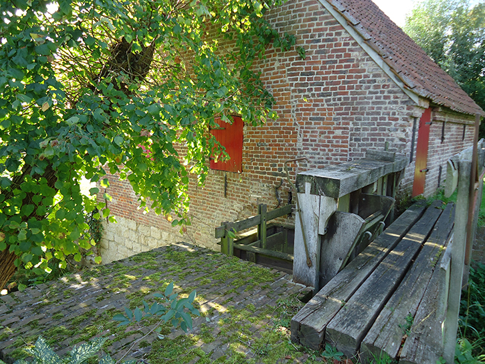
Willy Van Laethem bought the mill on September 26th 1969. At the time of purchase, the complete milling installation with three millstone couples was still present, but the water mill needed a full restoration in order to be able to continue with its original activity. The water wheel was partially rusted and in very poor condition, completely overgrown with weeds. The sluice was partially derelict and the wooden parts of the cam wheels fell apart at the slightest touch.
Very early after the purchase, Willy Van Laethem wanted to give the mill its old glory back. After many years of dedication, this dream has come true.
On March 3rd 1976, the mill and its surroundings were protected as a monument and as a village scenery (Royal Decree of October 23rd 1981).
The water management at Pede's Mill was not ideal. The current owner had a total restoration carried out by the company Verstraete from Rumbeke. This restoration started in 2001 and was completed in October 2002. During the restoration, a slightly smaller and wider water wheel was installed, in order to improve water management.
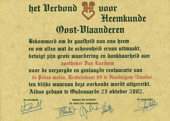
In 2002, after the restoration had been completed, a certificate was awarded to Willy Van Laethem by the « Verbond voor Heemkunde van Oost-Vlaanderen » (Heritage Society of East Flanders). We include a translation.
Illustration #4-10: Certificate.
« The Heritage Society of East Flanders, concerned about the conservation of our heritage and everything that contributes to its beauty, expresses its great appreciation and gratitude to pharmacist Van Laethem for the careful and successful restoration of Pede's Mill, Krekelstraat 99 in Hundelgem (Zwalm), in witness whereof this certificate has been granted. »
« Oudenaarde, October 25th 2002. »
Lime trees
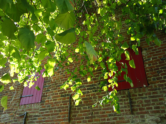
The Flemisch government has also protected both lime trees on the opposite bank next to the mill. They are on the territory of Velzeke and are part of the rural landscape, but have been granted the status of monuments.
These trees have a special function. They were planted to protect the wood of the dam and of the head race from the sun. The head race is a wooden construction that carries the water over the water wheel. Indeed, after a milling session, it is best to let the wood dry in shade. If left to dry in full sunlight, wood will expand and start to crack in the long run. We also notice that one of the trees was planted at an angle, with a pronounced inclination, to provide maximum shade for the mill.
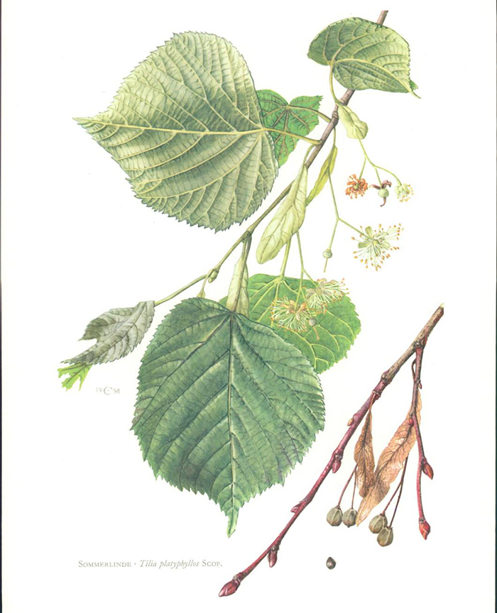
The lime tree (Tilia) is one of the largest deciduous trees endemic to Belgium. The broad-leaved lime tree or summer lime tree (Tilia platyphyllos) is a natural presence in the valleys of watercourses. This tree is characterized by its dome-shaped canopy of a considerable height. Because of its dense foliage, it is often planted as an ornamental tree or a shade tree in parks and gardens.
The lime tree is a very ancient indigenous tree, also known as the tree of life. The lime tree flower is ideal for making tea for colds and flu. In addition, the tree has a sweet-smelling bloom and is an important source of nectar for bees. The flowers are harvested with the bracts in full bloom and dry weather conditions. They are dried outside in the shade or inside a house in an attic.
Lime trees can reach a respectable age and a maximum height of 30 metres. The two trees next to the Pede's Mill have a trunk diameter of 2.40 and 1.80 meters respectively. To determine the age of a tree, not only the circumference of the trunk must be taken into account, but also the shape of the tree. In general, it is assumed that the circumference of the trunk of a lime tree increases by about 2.5 centimetres per year. A circumference of 2.50 meters could therefore indicate an age of 100 years.
However, other factors such as soil composition, climate and location have a significant impact on the growth rate. Therefore, a tree that has enough room to develop fully will develop a thicker trunk much sooner, while a tree that is enclosed by other trees or by a building will tend to grow more vertically.
The circumference of the trunk is therefore only a first indication. On the other hand , after about 150 years the growth pattern of the lime tree changes, because from this time on it hardly grows vertically but gets wider. More mature trees will develop a very high crown, while the base becomes wider. This characteristic silhouette is perfectly recognizable from a great distance. Young lime trees also have a smooth bark, while the more mature tree bark has deep furrows.
A conservative estimate of the age of the lime trees near the mill would indicate approximately 150 to 180 years. In any case, it is likely that the trees were planted after the transformation of the water mill in 1775, as the sluice was redesigned at this date. The bank where the trees were planted was slightly modified.
Cadastral data have revealed that the brook Passemarebeek is popularly known as « Lindebeek » (literally « Lime tree brook ») from the location of the Pede's Mill to its confluence with the Zwalm river. It is possible that it was named after the two lime trees that provide shade to the water mill and contribute to the idyllic character of this small building.
Furthermore, if we look at the way the Passemarebeek and the Lindebeek meet, it is not unlikely that the Passemarebeek is actually a tributary of the Lindebeek. A further indication is the name « Hof ter Linde » (literally « Lime trees Court ») where the two brooks meet.
In this part of Belgium, the lime tree would have disappeared from the woods in its wild form around 500 BC, but as the tree was often planted by man it is still common to this day. Traditionally, lime trees were planted in village squares and on farm yards. These trees can grow to a very respectable age. Several European specimens have a confirmed age of 800 to 1,000 years. The lime tree almost always gets a hollow trunk in old age.
The Germanic root lind- (in Old High German « linta », in Old English « linden » and in Swedish « lind ») goes back to the Indo-European word « lentos ». The Latin word « lentus » is also derived from this (= supple, flexible), which points to the particularly soft wood of the lime tree.
A very specific application of lime tree wood can be found in Le Dauphiné (Grenoble, France), where it is used in the manufacture of grain reservoirs. The wood of the lime tree is very soft. Rodents that try to bite the lime tree wood to get to the grain are bothered by the amount of fine powder this type of wood produdes.
The next chapter at a glance:
In which we make a short sketch of the Zwalm region and place it in a historical perspective.